Posts

Showing posts from May, 2021

Dr. Ram Bajaj Bikaner on Kerala Monsoon Delayed
Image
Date - 30 May 2021 Time - 7:00 p.m Dr. Ram Bajaj Bikaner on Kerala Monsoon Delayed. I.M.D is once again wrong in their declaration of "Set On" monsoon on Kerala. Still I.M.D can change the date. - Dr. Ram Bajaj Bikaner I.M.D announces delay in Kerala monsoon from 31st May to 3rd June 2021 than 28th May 2021 and now 3rd June. This may again be changed. What we said in our previous reports Date 21st May 2021 https://blog.rambajaj.com/2021/05/21-2021-8-1.html and 25th May https://blog.rambajaj.com/2021/05/25-2021-8.html please read and don't forget to write your review in comment box. Nobody can predict Kerala Monsoon 2021 but we still did it again. Detail report on 1st June 2021. Dr. Ram Bajaj Scientists and his team member and Engineer Dinesh Joshi and Raghav.

Dr. Ram Bajaj Bikaner in "Yaas" Cyclone.

Image
Date - 28 May 2021  Time - 10 am Dr. Ram Bajaj Bikaner in "Yaas" Cyclone. 1. Why the cyclone "Yaas" observations were purposely manipulated and  wrongly forecasted before the country by the various Indian weather agencies? - Dr. Ram Bajaj 2. A high power "fact findings" inquiry should be conducted for such a wrongful purposely fabricated "Very Severe Cyclonic Storm" Yaas with various sustained surface wind speeds 145-155 gusting to 185 kmph and positions of V.S.C.S at different dates along with "Landfall" position and timing of landing "Afternoon and evening of 26th May 2021". 3. While various other world famous weather agencies has observed some different data on tropical cyclone " Yaas then Indian weather agencies predicated " "V.S.C.S". 4. We have attached with some different normal observations its track  "Landfall" with normal wind speed of 55 kts to 61 to 65 kts by various multiple agencies.

डॉ. राम बजाज बीकानेर की "Yaas" तूफान पर सटीक Analysis जिसे कोई भी मौसम वैज्ञानिक नही कर सका।

Image
                                                                As reported by Aaj Tak  As reported by Hindustan Times Now you decide who is right दिनांक 26 मई सुबह 10 बजे डॉ. राम बजाज बीकानेर की "Yaas" तूफान पर सटीक Analysis जिसे कोई भी मौसम वैज्ञानिक नही कर सका। (1)जैसा हमने 25 मई 2021 की रात को सूचित किया था कि साधारण तूफ़ान 26 मई की सुबह 9 बजे से 10 बजेBaliapal, Digha, Chaudiparके बीच मे मात्र 95 km/h की तेज हवाओं के साथ landfall कर चुका हैं। एमडी वाले 145-155-185 km/h की अति भीषण - भयानक तूफान को Dharma port पर ही ढूढ रहे हैं। तूफान के बाद जगह जगह वर्षा भी लाज़मी है और समुंद्र का पानी- भी भरना लाजमी है। (2)सभी टीवी वाले- एंकर अभी की अति भीषण तूफान आने की प्रतीक्षा कर रहे - क्योंकि IMD के अनुसार दोपहर बाद टकराना था। जबकि land fall - सुबह 10:00 बजे ही हो गया। (3)कृपया तूफान Yaas के बारे में हमारी की गई- की गई 100% सटीक /Analysis की दोबारा जांच कर ले , जांचकरने के बाद हमे (4)शाबाशी देना नहीं भूले - नहीं भूले (5)दुनिया में साइक्लोन Yaas की इतनी बड़ी सटीक analysis करने वाला कोई
Image
  दिनांक 25 मई 2021 समय शाम 8 बजे डॉ.राम बजाज- बीकानेर का  "Yaas" - तूफान पर - सन-सनी खेज जानकारी - जो किसी भी मौसम वैज्ञानिकों ने सोची नहीं थी। - डॉ. राम बजाज   (1) हमने  दिनांक 25 मई की सुबह 10:00 बजे ही घोषणा कर दी थी - कि अति भीषण तूफान "Yaas", W. B.  राज्य के किसी भी तट से नहीं  टकराएगा -  जिससे W.B. राज्य - भारी नुकसान की आशंका पुर्णतः समाप्त हो जाएगी। (2) उपरोक्त हमारी घोषणा को IMD नकल करके - उजागर करने वाले हैं कि अति भयंकर तूफान अब उड़ीसा की ओर मुड़ गया है और W.B. राज्य पर खतरा टल गया है। (3)अति भीषण तूफान - अब हमारी बताई गई जगह पर ही - जगह पर ही -  दिनांक 26 मई की सुबह 9:00 से 10:00 के बीच Sore; Dhamra - Chandbali के आसपास तट से टकराएगा। (4) कृपया शाबाशी  देना - ना भूलें| (5) अब IMD  केरल के 28 मई को मानसून की तारीखों पर घमासान - मचाएगा। असल में केरल में मानसून का अता - पता ही गायब हो गया है। डॉ. राम बजाज (Scientist and his team member Dinesh Joshi) Note:- For more details visit our blog- https://blog.rambajaj.com/ 2021/05/dr-ram-bajaj-bikaner- on-cyclone-

Dr. Ram Bajaj Bikaner on cyclone "Yaas" on 26th May 2021

Image
  Date : 25th May 2021 Time: 10 Am    Dr. Ram Bajaj Bikaner on cyclone "Yaas" on 26th May 2021 Cyclone "Yaas" is very likely to move cross and landfall at Sore, Dhamra, Chandbali, Jambu, Kendrapara and Paradeep on 26th May 2021's Morning around 10 am. - For further updates please watch out for information by  Dr. Ram Bajaj 1. Putting complete -"W.B State" as a " red-red-red" alert by I.M.D is an astonishing matter. They have predicated extremely heavy rainfalls (means 200mm rain with in spam of 4hrs to 5hrs) at Jhargram, Medinipur, North and South 24 parganas , Hawrah, Hoogly and Calcutta and various other places. Places watch very carefully and report us back on 26th May and 27th May. 2. Remember the pressure bar will be 971 during landfall at    Sore, Dhamra, Chandbali, Jambu, Kendrapara and Paradeep having wind velocity 75 kmph to 84 kmph at 10 a.m. on 26th May 2021 and surface temperature of sea will be 28 Degree Celsius. 60 kmph  at Dega

Dr. Ram Bajaj Bikaner on Cyclone 'Yaas' (VSCS) in Bay of Bengal on 26th May 2021

Image
Date 24 May 2021 Time 10 A.M  Dr. Ram Bajaj Bikaner on Cyclone 'Yaas' (VSCS) in Bay of Bengal, on 26th May 2021. Cyclonic storm 'Yaas' in Bay of Bengal will never, never be  intensified into (VSCS) - Must check their parameter before declaring cyclonic storm into (VSCS) - Learn at https://blog.rambajaj.com/                                                                                                      तूफान  'Yaas' जो Bay of Bengal  में विकशित हो चूका हैं वह कभी भी - कभी भी (V.S.C.S) का रूप नहीं लेगा। मौसम वैज्ञानिक कृपया अपने आंकड़े दुबारा चेक कर ले। डॉ राम बजाज  बीकानेर  As per IMD - 1.  The depression over East Central Bay of Bengal moved from W.N Westwards  590km North - Northwest of Port Blair, 570km South - Southeast of Balasore (Odisha), and 650km South - Southwest of Digha (West Bengal) . 2. It has been intensifying into a cyclonic storm (Yaas) by 24th May morning (Today) and further into a Very Severe Cyclonic Storm (V.S.C.S) during the subsequent
Image
 दिनांक 21 मई 2021 समय रात 8 बजे Dr. Ram Bajaj Bikaner (A) (1). " दिल्ली मे ताउते और पश्चिमी विक्षोभ की  भिडंत से 19 मई में 24 घण्टे के दौरान 119.3 मि.मि. बारिश हुई। यानी 120 साल पुराना रिकॉर्ड टूट गया- IMD" - (डॉ. राम बजाज) (2). "यह कैसी भिड़ंत- राजधानी दिल्ली में हो गई और IMD को इस भिडंत का पता ही नही चला  (डॉ. राम बजाज) (3). हमने ऐसी भिड़ंत नही देखी l मौसम विभाग के इतिहास में भारत में-  इस तरह की 19 मई 2021 की भिड़ंत- क्या कहीं और भी हुई- या सिर्फ दिल्ली में हुई? जवाब IMD को देना होगा।- ( डॉ. राम बजाज) (4). जबकि IMD का prediction " Light to Moderate Thunder-storm over Delhi- NCR" दिनांक 19 मई 2021 नक्शे ओर prediction साथ में लगे हैं- जांच ले। (B) केरल के मानसून की तारीखों में IMD द्वारा छेड़खानी अब मौसम विभाग "मानसून" के आवागन की तारीख की छेड़खानी कर रहा है- केरल में मानसून 28 मई को पहुंच सकता है। - एमडी    कृपया IMD  के मानसून की घोषणाओ की तारीखों पर नज़र रखे। इनकी मानसून के आगमन की तारीखों का ऐलान असली मानसून से मेल नही खायेगी। ध्यान देवे। हम IMD
Image
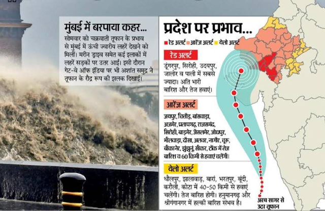
  18 मई 2021 IMD का राजस्थान में रेड ओर ऑरेंज अलर्ट - मात्र अलर्ट ही रहेगा। IMD विभाग द्वारा जारी रेड - ऑरेंज ओर यलो अलर्ट की घोषणा - राजस्थान के जीन जिलो में की है - वह सभी तथ्यों से बहुत दूर है। सिर्फ एक जिला उदयपुर रेड अलर्ट में आयेगा जबकि ऑरेंज अलर्ट मैं सिर्फ - तीन जिले होंगे और येलो अलर्ट में तेज हवाऐ चलेगी ओर सभी जगह सामान्य बारिश और बूंदा बांदी  के अलावा कुछ नही है- कृपया कल दिनांक 19 मई 2021 तक जांच ले। रात 11 बजे। डॉ.राम बजाज ( साइंटिस्ट) इंजिनीरिंग दिनेश जोशी ( टीम मेंबर)

Cyclonic Impact of Tauktae

Image
Date 17 May 2021 Time : 5 pm   Dr. Ram Bajaj                               Cyclonic Impact Of Tauktae 1.  हमने 16 मई रात 9 बजे को भयंकर तूफान Tauktae  के बारे में कहा था की I.M.D जितनी   भी Findings दी हैं वह गलत और Misleading हैं।   2. I.M.D के अनुसार  " Very Severe Cyclonic Storm "(V.S.C.S) गुजरात के पारबंदर से महुआ के 800 किलोमीटर लमबे तट के ऐसी भी भाग में 18 मई की सुबह 150 K.M.P.H  - 160 K.M.P.H की स्पीड से बहुत भयंकर तूफ़ान  "Tauktae" गुजरेगा उपरोग सभी तथ्य आज बिलकुल भी मेल नहीं खा रहे है - देखिये और समझे।  3. जबकि हमारा Findings और Analysis के आधार से यह बड़ा तूफान गुजरात के Una और Junagarh  के पास से होकर गुजरेगा और यही Landfall होगा  जो कल तक सभी को असंभव लगता था।  यहाँ कुछ नुकसान भी हो सकता है ।  4.  उना के पास लैंडफॉल (Landfall) होगा I.M.D और दुनिया के किसी भी मौसम विभाग के चैनल में नहीं की थी - हम एक बार फिर खर्रे (Correct) उतरेंगे ।  5.  कृपया उना के पास लैंडफॉल होते आप आज रात 17 मई 2021 12 बजे देख सकते है जरू जरू देखे।  6. और हमें धन्यवाद देना नहीं भूले ल

Cyclonic Impact of "Tauktae"

Image
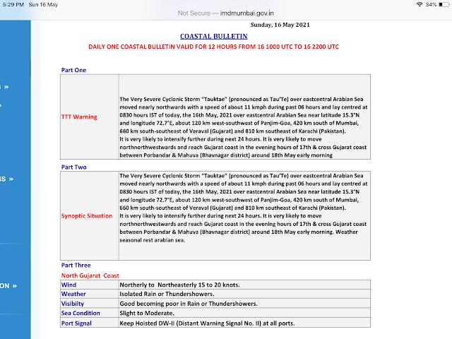
                                                                                                                  Date 16th May 2021                                                                                                                   Time - 9:00 pm  Dr Ram Bajaj Cyclonic Impact                                     Cyclonic Impact of "Tauktae" As per IMD, the Cyclone "Tauktae" has intensified into a very severe cyclonic storm (V.S.C.S) and is approaching the Gujarat coast. "It is very likely to move north - northwestwards and reach Gujarat coast in the evening hours of 17th May and cross Gujarat coast between Porbander and Mahuva (Bhavnagar district) around 18th May early morning. According to the cyclone warning division of the IMD by May 18, the wind speed is expected to increase to 150 - 160 K.M.P.H gusting up to 175 K.M.P.H (PTI) According to IMD, the diameter of the eye is roughly 4 K.M with an eye temperature of 5.2 Degree Celsius. The wall cl